Showing posts with label backpack. Show all posts

Saturday, October 20, 2012

Fall in NM


It's everybody's favorite season in New Mexico right now. The temperature is nice, the chiles are roasted and the tourists are keeping Old Town busy.


 A few weeks ago, we celebrated a milestone birthday for Hubbers by backpacking Hermit's Peak outside of Las Vegas. We took a circuitous route up El Porvenir Canyon, looped back over Hermit's Peak and came down the steep Hermit trail.

 The aspen were just beginning to think about turning yellow.

It rained lightly several times in the three days we were out there. But we still managed to get a campfire going so I could bake a birthday cake on it. We made it up and over the peak just before the storm clouds came in.

The birthday gift that I carried for two days in my backpack until I could give it to him.
It's still a bit too warm to be wearing a wool cap with ear flaps, but it should come in handy for skiing this winter. The hat pattern came from a free Ravelry download, but I made the Zia chart. See my project page for details.

Thursday, April 26, 2012

Canyonlands, part 2


Here's Part 1 if you missed it. This is a trip we took at the beginning of April. We had just two nights of camping in the backcountry of the Needles district, but that provided enough photographic wonders for two blog posts.

Here's our Chesler Park campsite for the second night. We got there relatively early because it was not a far walk from the first campsite.

After setting up our tent, we headed out for a long walk to find Druid Arch. Troy doesn't agree with the term slick-rock because the sandstone is actually quite grippy, nonetheless this trail started out along the slick-rock that the region is famous for. Just behind Troy you can vaguely see that there is a hole in the ground, a canyon in fact. Our hike was about to take us down into such a canyon.

Here we are at the bottom of the canyon, walking up a sandy wash southward toward Druid Arch.

Eventually, we reached the headwall of this drainage and climbed up a short ladder to reach the arch. It turns out that Druid Arch is part of a fin sticking out of the headwall, so it is impossible to see until you are right next to it.

Looking back toward Elephant Canyon, you can't see the bottom of the canyon with the sandy wash that we hiked in on. You can barely see the hints of treetops poking up from the bottom of the canyon.

Did you notice the gathering clouds in the last couple of photos? If you've read this blog before, you know what happens when we go camping in the desert… that's right, SNOW! (Examples from the past: Carlsbad, Gila, Chiricahua) The final morning greeted us cold and snowy.

Monday, April 16, 2012

Canyonlands, part 1


Can you believe that this place is only about 6 hours from my house but it has taken me 10 years to visit Canyonlands? It lived up to all of my expectations. Of course, we stopped first at Newspaper Rock, which I would re-name Archival Rock because I really don't expect to see new stuff up here each day.

We had two nights in the backcountry in the Needles District and because we had to carry all of our water, that was plenty of time. Here's our first campsite in Devil's Pocket. It turns out that the devil has a bunch of tumbleweeds piling up in his pocket like pocket lint.

 The highlight of the next day was hiking the Joint Trail. Joint means a gap between rocks. This part looks amazingly like a train tunnel:
 Then it gets narrower:
 Finally, we hiked out the end of the trail, then walked back above the trail to have a look. I'm sitting on the edge of the "joint" that I had just been hiking through a few minutes earlier. Amazing how straight, narrow and flat that trail is!

 Here's a nice panoramic of the Needles, overlooking Elephant Canyon. This is a sneak peak of our next day's hike.

Friday, March 30, 2012

Carlsbad

A couple of weekends ago we headed down to the Guadalupe Mountains near Carlsbad. Of course, we stopped by the Caverns first and "explored" the well-lit cave with a mob of other tourists on paved pathways with railings. It didn't really remind me of caving or give me that creepy feeling of being deep underground in an environment that humans simply were not intended to be in. But it is an enormous cavern!

Sunday, we headed out along Isolation Ridge in the Guadalupes. It was 50 degrees, cloudy and windy. Troy asked if it snows much in the Guadalupes. I thought he'd spent too much time in Texas if he thought that 50 degrees and clouds means snow.

 The next morning brought an answer to his question. Apparently he's not crazy.

We were not prepared for this. It was supposed to be warm, so we shivered all the way back to the trailhead. You can't see the 50mph wind in the photo (because we only stop for photos where we're protected from the wind), but you can tell it's there because the snow has been slammed into the sides of the plants not just the top.

After getting home, I asked the internet how often it snows in the Guadalupes and I found the park weather page, which tells me that we're lucky it was only 50mph wind and not 100mph. We were also lucky that it was snow and not a lightning storm. As we drove back down the dirt road that got us to this trail, we were hit with sleet, rain, hail and lightning. Glad we weren't hiking in that!

Friday, July 18, 2008

Kerry

As promised, here is the second half of the Ireland trip report. From Dublin, on July 5, we took the train to Killarney, in County Kerry on the southwestern end of the island. It's a peninsula with a lot of small towns hugging the coastline and the island's tallest mountains in the middle.

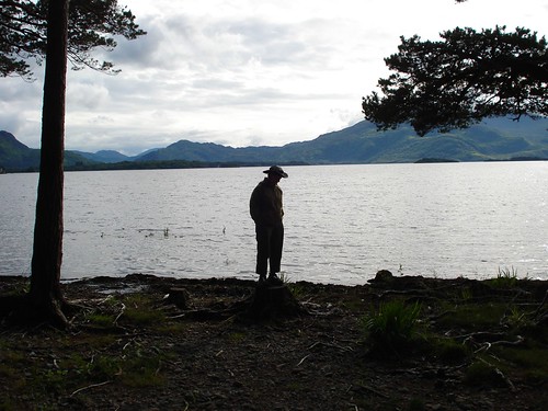
Killarney is a very touristy town next to a national park which contains a few lakes, including Lough Leane, where I'm standing below. We also explored the ruins of Muckross Abbey that evening. It's nice having such long days to see things. It didn't get dark until well after 10pm.

After a night camping in Killarney, we head out on the Kerry Way, a walking path that circles the peninsula.

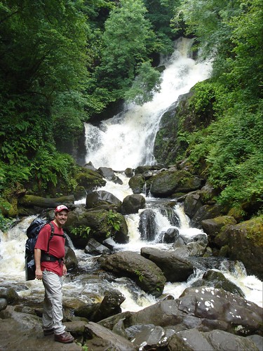
We stopped briefly at the Muckross mansion gardens, then hiked on up to Torc Waterfall (pictured below). All of the streams here are a funny brownish color, not unlike Guinness. This is due to the extreme acidity of the peat and heather lands on the tops of the hills and mountains.
The next photo is Black Valley, where we spent the night after enjoying some hot soup at a nearby tearoom. According to the trail guide, we walked 22km that day.

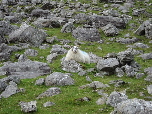
You asked for sheep... you get sheep... A lot of the hike was through sheep grazing territory. They seemed to prefer the cold, wet weather. When it was sunny, they'd all huddle close to their stone walls to get a piece of shade.

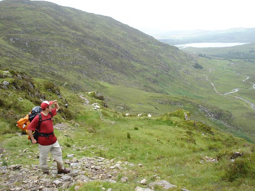
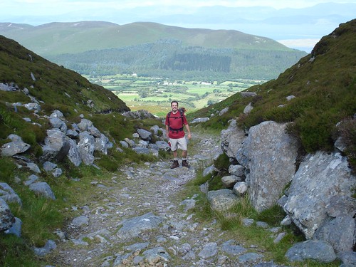
Hiking out of the Black Valley was rather miserable and wet at we went up and over two separate ridges. Then, fortunately we had a sunny afternoon (pictured below) as we trotted on down to Glencar. Glencar isn't much of a town, it simply has a few very scattered bed and breakfasts, and the Climber's Inn (a hostel). We enjoyed toasted sandwiches at the Climber's Inn, played a game of cards, and then headed out to pitch the tent in a nearby woods. A 20km day.
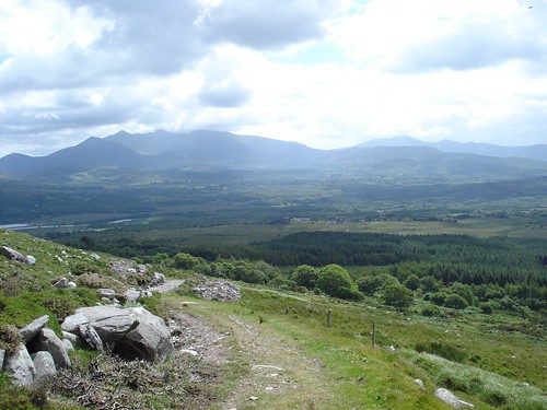
The third day of walking was great... a mere 15km with lovely weather. We took the shortcut through Windy Gap which took us over a low saddle. Looking back, we had this view:

Looking forward through the gap, we could see the fields outside of Glenbeigh, a bit of the ocean, and Dingle peninsula in the distance.
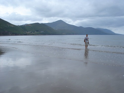
We spent an extra day at Glenbeigh, so that we could enjoy the beach at nearby Rossbeigh. The strand at Rossbeigh is quite long, but naturally, rather chilly to jump in the water. We sat on the beach, ate sandwiches, and read books until it started raining.

On Thursday, we took the long walk (28km) to Cahersiveen. This area was a bit more populated than the last few stretches. The day started nicely, and we left plenty early so that we could take some long breaks.
The photo below is looking back at the beach at Rossbeigh, it's the long strand of sand sticking out into the water.

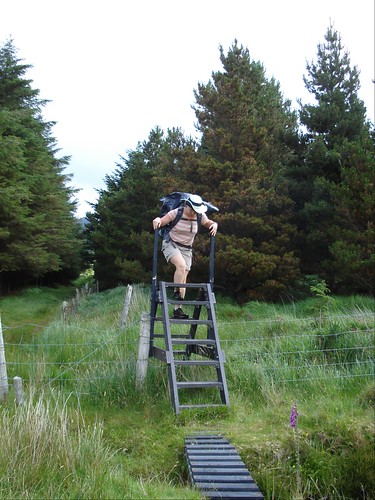
After a while, the day got a bit long. Then it also started to rain, which made it a bit unpleasant. As we went through more and more pastures, we had to climb up and over these ladders (pictured below) to get across fences. I can't even count how many of these we did... in addition to all the miles walked, this really tired out the legs. By the time we got to Cahersiveen, we were so tired, wet and smelly that we decided to stay at the hostel rather than put up the tent. After freshening up, we had some excellent seafood chowder and crab at a pub. We toured the town a bit the next morning before hopping on a bus to get back to Killarney.
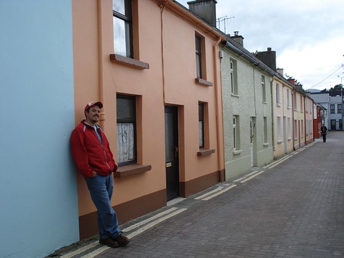
Below is a quiet street in Killarney, which is not easy to find. The town is really crowded with shops, pubs and people.
On Saturday, in Killarney, we toured Ross Castle, walked along the lake, and then hopped on a train back to Dublin. And then flew home the next day.

Monday, June 2, 2008

Vick's Peak

Due to technical difficulties, I am getting a bit behind on the blogging, so here's some photos from Memorial Day Weekend. Originally, we envisioned hiking up Wheeler Peak, near Taos... but snowstorms (in late May!) convinced us to go south. So, we ended up backpacking Saturday through Monday in the Apache Kid Wilderness, which is a mountainous area just west of Elephant Butte. In other words, it's in the middle of nowhere, but just a few hours south of Albuquerque. We hiked to the top of Vick's Peak because it was the tallest thing around and the hike was described in our 100 Hikes in New Mexico book. There is a whole network of trails back there, and a lovely pine forest. We camped on the saddle of a ridge next to an old miner's cabin. There really is not a trail to the top of Vick's Peak, but it wasn't far from the cabin.


Monday, March 24, 2008

In search of desert trails

Spring break (yay, grad school!) was last week and I had my heart set on backpacking through the desert, preferably surrounded by sculpted sandstone. I have always wanted to go to Canyon Lands in Utah, and this seemed like the right time of year, but we could not bring the dog hiking in a national park. Instead, we decided to hike a canyon in Escalante, a mere national monument which does allow dogs. We also had lift tickets for Durango Mountain that had to be used by the first Saturday of spring break. The trip quickly turned into a 4-corners area tour of sandstone.

After a pleasant day of skiing and trying out new telemark skis, we spent the night very near the 4-corners itself, just outside of the Navajo national monument. After a short hike in the morning to see the ruins at Navajo, we continued across northern AZ / southern UT (the roads are not straight) through Page, AZ, over the Glen Canyon Dam and on over to Escalante. We got our backcountry permit from the ranger station and drove out the mud road to our trailhead as it began to snow... rather a lot of snow. Suddenly the prospect of slogging through a few inches of water along the canyon floor in 30-degree weather wasn't sounding so nice.

We abandoned Escalante and went south, all the way to Sedona. It was still snowing there too, but we were led to believe that it would warm up, there were beautiful trails and we wouldn't have to slog through water. It did warm up over the next few days, the trails are gorgeous, but we did have to cross a deep "creek" and eventually could not complete our loop trail because it would have involved wading through waist-deep frigid water to get up-canyon to meet the other trail. We did spend 5 lovely days in the Sycamore Creek wilderness and saw some dramatic scenery and only a handful of other people.


Navajo Ntl Mon - can you find the ruins?


Lake Powell


Escalante Toad Stools (beware the clouds)


Sycamore Canyon, west of Sedona

It was incredible to realize how many amazing places are only a day's drive away from home. I already knew how great it is to be able to hike out of the Grand Canyon and drive home in the same day (it really makes those midwestern tourists jealous when you say "I'll be sleeping in my own bed tonight")... but to see just how many other beautiful desert places are nearby was a lot of fun. If you live out here, you should really make the time to go to these places, they aren't that far!